Tilişca | Judeţ: Sibiu | Punct: Dealul Căţănaş | Anul: 2006
Instituții și
Persoane implicate:
Persoane implicate:
| Nume | Prenume | Rol | Instituție |
|---|---|---|---|
| Goncear | Andrei | participant | Muzeual Naţional Brukenthal Sibiu |
| Popa | Dumitru | participant | Muzeual Naţional Brukenthal Sibiu |
Raport:
Cercetările din acest an au vizat alte două noi obiective propuse prin proiectul: Conservarea, restaurarea şi introducerea în circuitul cultural-turistic a Cetăţii dacice de la Tilişca, “Căţănaş”, proiect iniţiat de Direcţia Judeţeană pentru Cultură, Culte şi Patrimoniul Cultural Naţional Sibiu şi aprobat de Ministerul Culturii şi Cultelor, prin organismele sale de specialitate.
Prin alegerea lor s-a urmărit obţinerea de informaţii suplimentare la cele deja valorificate prin monografia staţiunii, cu privire la modalitatea de amenajare a centurii superioare de apărare şi eventual a unor precizări cronologice cu privire la aceste amenajări, iar în cazul celui de al doilea obiectiv, cu privire la planimetria, tehnica de construcţie şi starea de conservare a celui de al doilea turn locuinţă din cetate.
Prima arie de interes a fost zona denumită de N. Lupu “marginea întărită a platoului superior”, situată la V de turnul principal (T1), sub terasele 3 şi 41. Rezultatele preliminare ale sondajelor din anul acesta indică faptul că această zonă este o terasă amenajată, ce mărgineşte platoul superior către NV, pe o distanţă de peste 400 m.
Scopul săpăturii pe această terasă este dublu: determinarea amenajării propriu-zisă a terasei, dinamica ocupării terasei.
Sezonul 2006 a avut ca obiectiv studierea ultimei faze de amenajare a zonei, corespunzătore ultimei perioade La Tène.
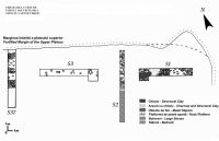
Au fost excavate trei secţiuni magistrale pe această terasă, situate între secţiunile 1 şi 37 ale lui N. Lupu. Două dintre ele, S1 şi S3, de 10 x 1,5 m, au fost trasate paralel cu marginea platoului, la aprox. 5 m de aceasta. S3 începe la 5 m E de secţiunea 37 (săpată de către N. Lupu) şi continuă 10 m către E. S1 începe la 11,5 m E de extremitatea lui S3. Extremitatea vestică a lui S1 şi cea estică a lui S3 au fost casetate (2 x 2,5 m). S2 (15 x 1 m) este situată între S1 (la 4 m) şi S3 (la 6,5 m), perpendiculară cu marginea platoului (şi cu axul S1-S3), începând la 1 m S de această margine. Vegetaţia densă şi mai ales prezenţa unor copaci masivi au fost un factor în determinarea poziţiei secţiunilor.
Toate secţiunile prezintă un strat vegetal de 0,25 - 0,30 m. S1 prezintă sub stratul vegetal o evoluţie orizontală E-V după cum urmează. În extremitatea estică, pe o distanţă de 2 m apare un nivel de bolovani (piatră spartă şi de râu) de dimensiuni variabile (0,10 - 0,70 m), care se continuă încă 2 m cu un amestec de pământ lutos maroniu gălbui şi bolovani disparaţi. De la limita nivelului de bolovani, începe o platformă de aprox. 0,10 m gr. de piatră spartă (de talie sub 0,05 m) compactă care continuă cca. 2 m spre V, unde începe să fie acoperită de un strat de pământ lutos maroniu, bogat în urme de arsură şi chirpic. Acest ultim strat continuă până la extremitatea vestică a secţiunii, unde se suprapune cu o zonă de mare concentraţie de chirpic. Chirpicul este mărginit la N de bolovani şi la S de piatră spartă compactă. În jurul concentraţiei de chirpic au fost găsite numeroase obiecte de fier (o lamă de cuţit, două vârfuri de lance, o cataramă, elemente de harnaşament, cuie). În jumătatea estică a secţiunii, săpătura a fost continuată în adâncime. Sub platforma de bolovani, a apărut stânca (la o ad. de 0,60 m la extremitatea estică a lui S1), ce urmează o pantă foarte lejeră la extremitatea estică a secţiunii şi din ce în ce mai accentuată către NV. La 1 m de extremitatea estică a secţiunii, a apărut o groapă cu un d de 0,55 m, săpată în stâncă până la o ad. de 0,60 m. Pe fundul gropii apar urme puternice de arsură. Umplutura este compusă din pământ negru, cu mult cărbune şi cenuşă, şi numeroase fragmente ceramice.
În S2, în jumătatea sudică a secţiunii, stânca apare imediat sub nivelul vegetal (o monedă din 1859 a fost găsită pe stâncă) şi urmează o pantă din ce în ce mai accentuată către N. În capătul nordic a secţiunii, pe o L de 5 m, apare un nivel de bolovani care se continuă 2 m cu o platformă de piatră spartă compactă, ca în S1 (şi în S37). Sub nivelul de bolovani se profilează partea superioară a unor elemente de construcţie.
S3 a fost foarte afectată de rădăcini. Sub stratul vegetal propriu-zis, apare un strat cu câţiva bolovani împrăştiaţi. Sub nivelul de bolovani, apare un nivel steril de 0,50 m de lut galben nisipos. Sondajul a fost coborât un nivel în jumătatea vestică a secţiunii. Sub nivelul de lut a apărut un nivel cu arsură puternică, bogat în fragmente ceramice.
Rezultatele preliminare ale acestei cercetări indică faptul că această terasă a avut o funcţie mult mai complexă decât o simplă întăritură a valului superior (concluzie exprimată de către N. Lupu din rezultatele secţiunilor 1, 17, 18, 19, 37)2.
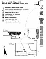
Al doilea punct cercetat a fost aria ocupată de amenajările turnului 2 (T2), situat la extremitatea estică a platoului superior. Scopul săpăturii a fost stabilirea cât mai precisă a structurii turnului şi a elementelor structurale asociate, identificate de către N. Lupu dar fără ca să ofere mai multe informaţii. Opt secţiuni au fost identificate pe teren din săpăturile anterioare: 4, 13, 14, 15, 28, 29 (menţionate de către N. Lupu)3 şi încă două nemenţionate. Trei secţiuni au fost săpate. Prima secţiune a avut ca scop curăţarea secţiunii 28 a lui N. Lupu pentru stabilirea unui profil continuu N-S prin interiorul turnului, de la limita “terasei intermediare”4 până la versantul, foarte abrupt, al platoului către satul Tilişca. S4 N şi S4 S, au avut ca scop dezvelirea eventualelor resturi ale zidului de V al turnului. Săpătura a scos la iveală un puternic strat de arsură, de peste de 0,30 m gr., în exteriorul turnului, în care au fost găsite scânduri (?) şi bârne carbonizate, acoperit de un strat masiv de moloz cu fragmente mari de cărămidă, urmat de un strat vegetal de grosime variabilă. De asemenea a fost identificată zona săpată de localnici pentru extragerea blocurilor fasonate, ceea ce explică dispariţia completă a zidului vestic, inclusiv a emplectonului.
În secţiunea 28 a fost surprins emplectonul şi trei blocuri de calcar fasonate din paramentul exterior al zidului de N. În exteriorul zidului N, apare o platformă de aprox. 2 m formată pe primul metru de stânca fasonată şi continuată încă 1 m printr-o structură de zidărie neregulată realizată cu piatră spartă. Această platformă pare a marca extremitatea estică a centurii superioare, aşa cum a fost ea denumită de prof. N. Lupu. Observaţiile preliminare par să indice că “terasa intermediară” este mult mai târzie şi a rezultat din amenajarea unui drum pentru căruţe care ocoleşte movila cu laturi abrupte formată din resturile turnului, ca atare nu este o amenajare antică. În interiorul turnului, s-au găsit resturi din podina de lut/pământ compactat care forma o platformă orizontală, completând astfel amenajarea stâncii, acoperită de un strat de arsură de 0,03 - 0,10 m, urmat de un strat masiv de moloz. Poteca modernă trecând prin mijlocul turnului a afectat foarte mult stratigrafia din interiorul structurii.
Lucrările de cercetare din acest an s-au executat între 25 iulie şi 15 august, iar la ele a participat şi o echipă internaţională de voluntari de a căror recrutare s-a ocupat prof. Andrei Goncear.


 CC BY-SA 4.0
